Multipitch Atlas

Salü Jan

Pfadflue · Gastlosen · Switzerland

Bail with caveatsBolting confidence: high

One of the busiest routes in the Gastlosen: homogeneous, technical climbing on beautiful fluted slabs (cannelures) that dry fast. The top third is broken by grassy ledges.

Overview of the Salü Jan sector on the Pfadflue, GastlosenPhoto: alexduchablais · CC BY-SA 3.0

Photo

Overview of the Salü Jan sector on the Pfadflue, GastlosenPhoto: alexduchablais · CC BY-SA 3.0
Hardest pitch
6a
Pitches
12
Length
380 m
Approach
40 min
Aspect
S
South-facing
Rope
2×50 m

The route

Overview

Salü Jan climbs the full south face of the Pfadflue (Grand Pfad) in the Gastlosen: about 380 m, 11 climbing pitches plus one grassy gully, from 1715 m to just below the 2066 m summit. The climbing is steady 5a to 5c slab and water-runnel (cannelure) work with one awkward 6a wall near the top. It is one of the most popular routes in the range, the rock dries fast, and the belays are chained. The upper third is broken by grass ledges, the bolts are far enough apart that you want a margin on the grade, and the abseil descent has one well-documented trap.

The climbing

Pitch by pitch

Pitches of Salü Jan
PitchGradeNotes
P15bLow-angle slab.
P24cShort. Slab, then a 10 m traverse right (red arrow) along a grassy ledge to the belay. One party missed the traverse and climbed too high.
P35aSteeper slab and runnels; traverse left at mid-height where 'Salü Jan' is painted.
P45a+Either straight up a good runnel (5a+) or left up a more compact slab (5c); the two lines rejoin before the belay, which is slightly left. A third bolt line further right does not seem to reach the same belay.
P55bShort, slightly overhanging wall, then left and back right up a short runnelled slab. Watch the rope drag.
P65bA fine runnelled slab to the big grass ledge.
P7walkGrassy gully slanting up left. No climbing.
P85c+Technical runnelled slab, the best pitch of the upper part.
P95bSlab to a belay that is used on the descent, then grassy steps to the belay below a steep step.
P105cClimb the step on its left, then a technical slab.
P116aCrux: a tricky little wall, then easy grassy steps to a belay (used on the descent). Traverse a few metres right to the belay below a small pillar.
P125aUp the pillar, then an easy ridge to the last belay, not far from the summit.

Getting there

Approach

To the parking

Base is Jaun (Fribourg), reached from the motorway at Bulle. Two trailheads. Oberi Bire (1730 m): from Jaun take the Abländschen road and turn left at the hairpin just before the village, then up to the parking before the Mittelberg col; camptocamp says the road beyond is closed to traffic (30 min by bike or 45 min on foot to Oberi Bire), although several recent trip reports say they parked at Oberi Bire itself. Filidor reported in July 2025 that parking along the whole Ruedersbergstrasse is now banned and cars must use the fenced, signed bays at the Mittelberg/Ruedersbergstrasse junction, adding 15-20 min to approaches on that side. Oberberg (1490 m): after Jaun turn right towards Abländschen, after 4 km go right at the 'Grat' sign and follow 'chalet Grat' signs for about 3.5 km; park just after the second crossing of the Büelsgraben stream (pay parking, CHF 7 per camptocamp). No public transport to either trailhead; a seasonal bus runs Jaun-Saanen (daily in school holidays, otherwise weekends, May to October).

On foot · about 40 min

30-45 min. From Oberi Bire follow a well-marked contouring path north to a shoulder on a ridge below the SE face of the Gross Turm at about 1800 m. Drop into the valley to the north and traverse left across the slope to a scree fan that leads to the foot of the route. From Oberberg, climb the bank and take the path up the wooded valley heading WSW to the foot of the Pfadflue. The route name is painted in yellow at the base.

Finding the route · 1 photo

Approach photo

Map of the walk-in

  • Crag
  • Parking
  • GPS line

Loading map

The point marks the crag, not the exact start of the route.

GPS line: a line of the walk-in and the descent drawn by its source, not a recorded track. Line attached to the camptocamp route page: a 3.4 km round trip that starts and ends on the Oberi Bire side (south of the Pfadflue), not at Oberberg. Do not follow it blindly.

GPS line: camptocamp contributors · CC BY-SA 3.0

Coordinates · crag

46.57867, 7.27381

Parking

46.58247, 7.28730

Oberberg (camptocamp access point)

Point from camptocamp waypoint 41643

For your phone or watch

Download GPX

Contains the route point, parking and a GPS line. Opens in most mapping apps and GPS watches.

Points are compiled from published sources, with the precision stated above. They were not surveyed on the ground: check them against a current topo.

Getting down

Descent

Abseil, following red arrows and marks, in nine stages. (1) 25 m down grass to an anchor to the left; you can instead walk down the grass slopes on the left (looking out from the summit) and traverse along a track to this anchor, best in approach shoes. (2) 45 m straight down (red arrow) to an offset anchor in a grassy gully. (3) 45 m down the grassy gully, a low-angle abseil or a walk, to the anchor you passed on pitch 9. (4) 50 m straight down to the big grass ledge. From here use the neighbouring route Hallo Marco, whose top anchor is at the edge of the ledge and whose belays are doubled: (5) 30 m down Hallo Marco's last pitch to its R5, (6) 45 m from R5 to R3, which is under an overhang marked 'bar', (7) 40 m from R3 to R2, (8) R2 to R1, (9) R1 to the ground. A 2026 party took 1 h for the abseils.

Retreat

Bailing off the route

Bail with caveats

Yes, abseiling is the normal way down and the belays are chained, but the line needs care. From the big grass ledge after pitch 6 you must go down the neighbouring route Hallo Marco, not from Salü Jan's own R7. A party who abseiled from R7 in 2020 ended up in a stonefall gully near the end of their 50 m ropes and needed help.

Retreat from
The big grass ledge after pitch 6 and the belay passed on pitch 9 are the usual turn-round points; several parties climb only the first five or six pitches and abseil. From the ledge, five abseils down Hallo Marco (30, 45 and 40 m, then two shorter) reach the ground. Retreat from Salü Jan's own belays below the ledge is not described; pitches 2 and 3 include traverses.
Carry
2×50 m ropes; abseils are up to 50 m. Knot the ends.
Basis
Part stated, part inferredCamptocamp states the abseil descent, the chained belays, the recommendation to descend Hallo Marco from the ledge and the 2020 incident; that you could also abseil from the chained belays of pitches 1 to 5 is an inference and is not described by any source.

Partly inferred from the route facts

Safety

Hazards

  • Abseil trap at the big grass ledge: do not abseil from Salü Jan's own R7. A party who did so in November 2020 ended up in a vertical gully off route and exposed to stonefall, almost at the end of their 50 m ropes, and needed help from other climbers to regain Hallo Marco. From the top of the ledge, look for the Hallo Marco anchor to the left (facing the wall).
  • Bolt spacing: a 2025 report calls the equipment 'fairly spaced' and says you need a margin on the grade, even though camptocamp rates it P1 with chained belays.
  • The line crosses an old route, 'Parc à Moutons', several times; that route is on 8 mm bolts. Do not follow the old hardware.
  • Grass: the top third has many grassy breaks and the first abseil and one middle abseil come down grass slopes. Slippery when wet; take shoes for the summit ledges.
  • Popular route with abseils down climbed terrain: expect parties above and below.

Sun and weather

Conditions

South facing at 1700-2070 m and quick to dry. It can be hot in summer; trip reports show it climbed from May to late November, and in late autumn it is pleasant in the sun but cold as soon as the shade arrives. The sector is one of the busiest in the Gastlosen: on one September 2026 Saturday four parties started the route and all turned back at half height.

Usual season · May to Oct

Sun on the wall · S-facing

Working out the sunlit hours for this month.

  • January: not yet worked out
  • February: not yet worked out
  • March: not yet worked out
  • April: not yet worked out
  • May (usual season): not yet worked out
  • June (usual season): not yet worked out
  • July (usual season): not yet worked out
  • August (usual season): not yet worked out
  • September (usual season): not yet worked out
  • October (usual season): not yet worked out
  • November: not yet worked out
  • December: not yet worked out

Sun on the wallDaylight, wall in shade● Usual season

Estimated from the wall's aspect only. Ignores surrounding terrain, gullies and the wall's exact shape. Clock times are local to the wall (Central European time), for the 15th of each month.

Monthly climate averages for Gastlosen, 1991-2020
MeasureJanFebMarAprMay (usual season)Jun (usual season)Jul (usual season)Aug (usual season)Sep (usual season)Oct (usual season)NovDec
Mean daily high °C−3−225101416161292−2
Mean daily low °C−11−10−7−5−14663−1−6−10
Rain days 1 mm or more141214162020201815131314
Sunshine hours a day6.17.38.810.410.911.812.211.19.58.06.45.5

● marks the usual climbing season. Averages for 1991-2020 at about 1766 m. Area climate from Open-Meteo reanalysis (about 10 km grid): the wall and valley can differ. Data: Open-Meteo, CC BY 4.0.

What to carry

Gear

2×50 m ropes, 12 quickdraws, helmet. No trad gear is listed by any source.

Checklist

Quickdraws
12
Rope
2×50 m
Helmet
One each
Abseil device and prusik
The descent or the retreat involves abseiling

Derived from the route data; check it against a current topo

From climbers

Reader reports

Reader reports are not being collected yet. Until they are, check a current topo and the local club or guidebook publisher for recent changes to Salü Jan.

Worth knowing

Tips

  • If time is short, stop at the big ledge after pitch 6 or at R9 and abseil from there; several parties do only the first five or six pitches as an introduction.
  • A popular link-up is Hallo Marco (six pitches, 5b, 5a, 5b, 6a, 6a, 5c) to the ledge, then the last five pitches of Salü Jan.
  • A 2026 party felt the Plaisir West guide undergrades some pitches and found the camptocamp grades closer.
  • On pitch 4 the right-hand runnel is the easy option (5a+); the left-hand slab is 5c.
  • Accommodation: campsite in Jaun; dormitories at Chalet Grat, the Chalet du Soldat and in Abländschen. Camping is forbidden at Oberi Bire. At Oberi Bire cows may scratch parked cars; some park 100 m before the barrier.

Open questions

Where sources disagree

  • Pitch grades: the current French camptocamp description (followed here) gives 5b, 4c, 5a, 5a+, 5b, 5b, walk, 5c+, 5b, 5c, 6a, 5a. The older Spanish translation on the same page has 5a for pitches 1 and 5, 5c for pitch 8 and 5b for pitch 12. A 2026 trip report gives the top five as 5c+, 5b, 5c, 6a, 5b.
  • Access: camptocamp's Oberi Bire page says the road is closed beyond the Mittelberg parking, a Gulliver report says the road to the Grand Orgue and Oberi Bire parkings is closed to motor vehicles, and Filidor (2025) describes new parking rules on the Ruedersbergstrasse; yet 2020 and 2026 trip reports say they parked at Oberi Bire with a 30 min approach. Check the signs on the day.
  • Bolting: 'good, chained belays' (camptocamp description) versus 'fairly spaced' (2025 trip report).
  • All route detail comes from camptocamp (description plus trip reports); the other sites only cover access and the area.

Provenance

Sources

Around 6a · about 12 pitches

Similar elsewhere

No photo yet

Italy · Val d'Ossola

Il Cammino del Sole

Twelve long pitches of sunny gneiss slab above Oira, mostly 4c to 5b+ with two 6a pitches: a thin slab at the start and an athletic corner on pitch 10. Pitches are up to 55 m. A winter-sun route with a summit book and plaques at both ends.

6a12 pitches530 m
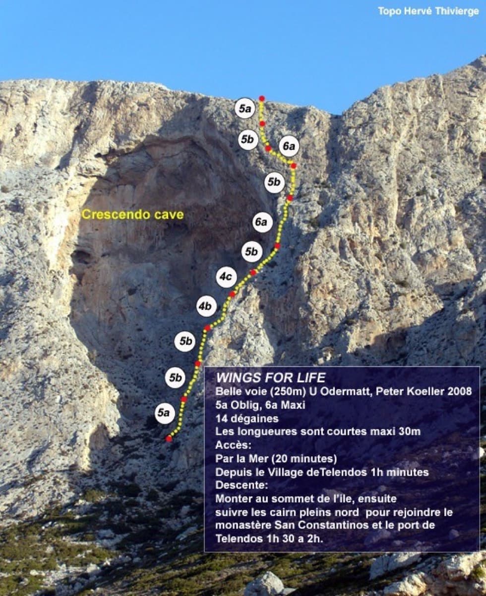
Topo of Wings for Life, right of the Crescendo cave, Telendos south face

Greece · Kalymnos & Telendos

Wings for Life

The first route on the wall (Odermatt and Keller, 2008), climbing a long, exposed line on sharp, grippy rock right of the huge roof. The lower pitches are easy for the grade. The two 6a cruxes are a short odd corner over a small roof and a traverse high up, and they come with big exposure. Pitches are short, so you can link them with long draws.

6a11 pitches250 m

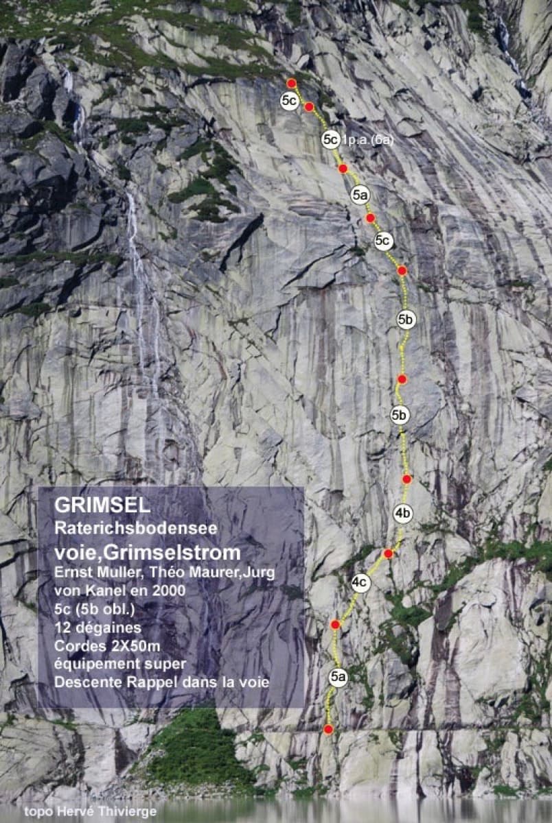
Photo-topo of Grimselstrom on the Seeplatten above the Räterichsbodensee, Grimsel

Switzerland · Grimsel

Grimselstrom

Glacier-polished slabs straight above the Räterichsboden dam. Four warm-up pitches lead to sustained 5b–5c slab and a short fissured roof (6a or A0).

6a11 pitches220 m

Read the cautions

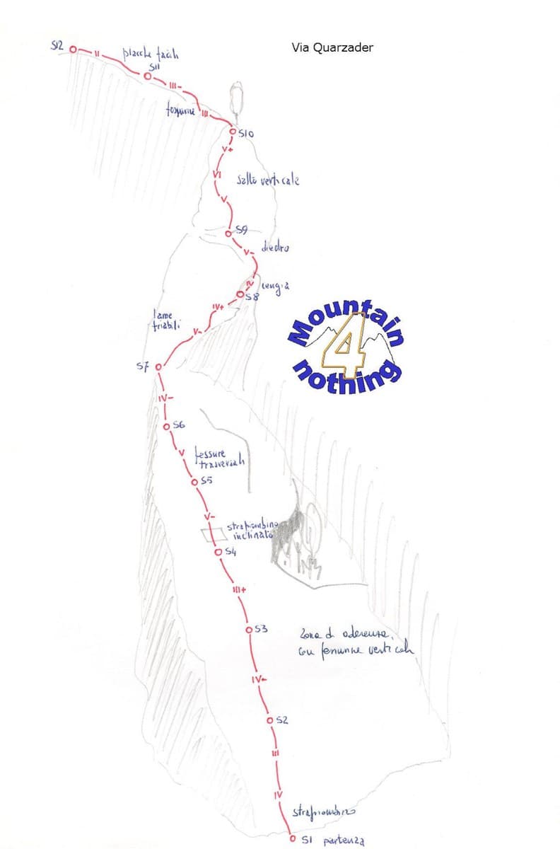
Hand-drawn topo of Quarzader on the Speroni di Ponte Brolla

Switzerland · Ticino

Quarzader

Slab pitches give way to a vertical wall threaded with quartz veins, which gives the route its name. It is shady in the morning, and the pitches are short (about 35 m), so 11 go quickly.

6a11 pitches400 m

Compiled from published sources and last verified October 2026. Bolts, anchors and access change. Climbing is dangerous and you are responsible for your own decisions: check a current topo and read the disclaimer.