Multipitch Atlas

Remix

Miroir d'Argentine · Vaud Alps · Switzerland

Read the cautionsBail with caveatsBolting confidence: high

The bolted way up the Miroir d'Argentine: fourteen pitches of compact limestone slab, with the difficulties in the first four pitches and long, easy, run-out friction above. A big day out at a modest grade with a mountain walk-off. Do not underestimate it.

The Miroir d'Argentine seen from SolalexPhoto: Jean Raymond · CC BY-SA 3.0

Photo

The Miroir d'Argentine seen from SolalexPhoto: Jean Raymond · CC BY-SA 3.0
Hardest pitch
5c+
Pitches
14
Length
400 m
Approach
60 min
Aspect
NW
North-west-facing
Rope
1×50 m
(walk-off); 2×50 m if you want to be able to retreat
Read before you go

Fully bolted and reinforced in 2022, but long, run-out on the easy slabs and exposed to stonefall from other parties.

The route

Overview

Remix is the classic moderate bolted line on the Miroir d'Argentine, the 400 m limestone slab above Solalex. The first four pitches (5b+ to 5c+) are the steepest and hold the difficulties; above, the angle eases into long slabs of 4a to 5b, a roof and a blocky section on pitches 9 and 10, then easy ground to the ridge. The route is fully bolted and was reinforced in 2022, but it is not closely bolted: the cruxes are well protected and the easy slabs are run-out. It is very popular, the face holds snow above it until early summer, and the descent is a proper mountain path. Treat it as an alpine day at a sport grade.

The climbing

Pitch by pitch

Pitches of Remix
PitchGradeLengthBoltsNotes
P15b+35 m7 boltsStraight up above the name, then a step left. A good warm-up pitch.
P25c25 m7 boltsA thin traverse left, then straight up to a wide ledge. Do not use the gold-coloured belay: go slightly left and up to a second small terrace, to a belay below a bolt with a maillon, with 'Remix' painted in red to its left. Other belays 2 to 3 m left and lower down belong to other routes.
P35c+35 m9 boltsThe crux pitch, more impressive than hard. Belay left of the crack (camptocamp places it at 30 m).
P45b+35 m8 boltsA thinner move 5 m above the belay, then straight up on slabs with spaced bolts but nothing hard.
P54c+30 m6 boltsSlab, 30 to 35 m. Keep left to stay on route.
P64b35 m5 boltsSlab and small steps.
P75b35 m8 boltsClimb more or less straight up. Keep left.
P85b35 m6 boltsSlab trending slightly left. At the belay you see the red marks of the continuation.
P95b35 m7 boltsFollow the red marks. Pass an overhang and follow a wide crack for 5 m. Manage rope drag.
P105b25 m6 boltsClimb into blocks on the left. An airy traverse left avoids a perched block. Pull over the final overhang on good holds, then a 5 m ramp to a comfortable belay on the left. Manage rope drag.
P114a40 m6 boltsA small step, then slabs trending slightly left, with another small step before the belay.
P124c40 m5 boltsSlab, then trend right along the fracture.
P133c40 m5 boltsFollow the crack on the right and turn a small step, then aim right of the red marks.
P143b40 m3 boltsEasy climbing to the ridge. The belay is about 5 m below the crest.

Getting there

Approach

To the parking

From Bex or Villars drive via La Barboleuse to Solalex (1462 m), where parking is paid (7 CHF a day reported in 2026). By public transport take the BVB train, then a bus from La Barboleuse and the seasonal postbus to Solalex, which runs from June to mid-September; a 2025 party found its hours (arrival 08:55, last return about 17:00) too tight for the route. In winter the road is closed below Solalex.

On foot · about 60 min

From the lower Solalex car park drop slightly to cross the stream on a footbridge, go immediately left across a field and pick up a path on the right (marked posts, red mark). Climb steeply to the foot of the wall. After a dog-leg right the path returns to the top of the scree cone. Follow the base of the wall leftwards, past the Voie du Y (name on a metal plate) and Papageno (name in red). A descent of about ten metres leads to the start of Remix, also painted in red. 45 minutes to 1 h 10.

Finding the route · 3 photos

Approach photo

Map of the walk-in

  • Crag
  • Parking
  • GPS line

Loading map

The point marks the crag, not the exact start of the route.

GPS line: one party's recorded GPS track of the whole day, including the climb and the descent. One party's recorded day on 15 July 2025 from Solalex: walk-in, climb and descent (about 3.2 km). Do not follow it blindly.

GPS line: dereuxromain · CC BY-NC-ND 3.0

Coordinates · crag

46.27684, 7.14380

Parking

46.28833, 7.13732

Solalex (camptocamp waypoint 111683)

Point from camptocamp waypoint 39005

For your phone or watch

Download GPX

Contains the route point, parking and a GPS line. Opens in most mapping apps and GPS watches.

Points are compiled from published sources, with the precision stated above. They were not surveyed on the ground: check them against a current topo.

Getting down

Descent

Walk off. Traverse left and follow a stony path along the south-east side of the Haute Corde to its summit; a bolted 6a+ pitch (Le dessert) also leads there. From the Haute Corde follow the east-north-east ridge and descend directly to Solalex by a steep, loose path through the Poreyrette gully. If the ground is wet, go round by Anzeinde instead, about half an hour longer but safer. Allow 1 h 15 to 2 hours.

Retreat

Bailing off the route

Bail with caveats

Retreat is possible but needs two ropes: camptocamp says abseils of at least 40 m are required to go down from belay to belay. Each belay has two bolts since 2022, usually a bolt and a ring, so carry slings and maillons. It gets less attractive the higher you are, with 14 pitches below and other parties climbing up the line.

Retreat from
Any belay, with two ropes.
Point of no return
Not defined in the sources. After pitch 4 the climbing is much easier, so above there continuing to the ridge is usually quicker than a dozen abseils.
Carry
Two ropes of at least 40 m, slings, a few maillons.
Basis
Part stated, part inferredCamptocamp states that abseils of at least 40 m are needed to descend belay to belay; belay hardware and the practical turn-round point are inferred.

Partly inferred from the route facts

Safety

Hazards

  • Run-out easy slabs. A 2025 party counted only 3 to 6 bolts on each of the last four 40 m pitches, and Mountain Project describes pitches 5 to 10 as run-out. The climbing there is easy but a fall would be long.
  • Stonefall. The face is popular (more than ten parties on the Miroir on a July Saturday), there are loose stones on the ledges, and one party saw a rucksack fall the length of the wall.
  • Rope drag on pitches 9 and 10.
  • Easy to pick the wrong belay at the top of pitch 2, where several routes meet.
  • The direct descent through the Poreyrette is steep and loose, and dangerous when wet.

Sun and weather

Conditions

North-west facing between about 1900 and 2300 m; the sun does not reach the face before midday. Do not go on the face while there is still snow on the slopes above: blocks of snow and stones fall down it. In late June 2025 there was snow below the wall but an easy gap to reach the start. After a morning shower the face was dry enough two hours later, with seeping cracks. It can be very hot even in the shade in a heatwave.

Usual season · Jun to Sep

Sun on the wall · NW-facing

Working out the sunlit hours for this month.

  • January: not yet worked out
  • February: not yet worked out
  • March: not yet worked out
  • April: not yet worked out
  • May: not yet worked out
  • June (usual season): not yet worked out
  • July (usual season): not yet worked out
  • August (usual season): not yet worked out
  • September (usual season): not yet worked out
  • October: not yet worked out
  • November: not yet worked out
  • December: not yet worked out

Sun on the wallDaylight, wall in shade● Usual season

Estimated from the wall's aspect only. Ignores surrounding terrain, gullies and the wall's exact shape. Clock times are local to the wall (Central European time), for the 15th of each month.

Climate figures for Vaud Alps are not available yet

What to carry

Gear

12 quickdraws, slings to link the two belay bolts, helmet. Camptocamp and Mountain Project both suggest a few small cams (about 0.4 to 1) to shorten the run-outs; they are not essential and placements are not always available on the slabs. A single rope is enough for the climb, but retreat needs abseils of at least 40 m.

Checklist

Quickdraws
12
Rope
1×50 m (walk-off); 2×50 m if you want to be able to retreat
Helmet
One each
Slings
Mentioned for retreat
Maillons or spare karabiners
To leave behind if you retreat

Derived from the route data; check it against a current topo

From climbers

Reader reports

Reader reports are not being collected yet. Until they are, check a current topo and the local club or guidebook publisher for recent changes to Remix.

Worth knowing

Tips

  • Allow 5 to 7 hours on the route; fast parties moving together on the upper slabs take 3.5 hours.
  • The difficulties are over after pitch 4 and the pace picks up as the angle eases.
  • Start early at weekends to be ahead of the queue and of anything other parties knock down.
  • Clip your rucksack to the belay whenever you take it off.

Open questions

Where sources disagree

  • Grade: 5c+ on camptocamp; Mountain Project gives 5.10a/b, which it equates to 6a+, for the crux third pitch.
  • Bolt count: camptocamp says about 120 bolts are in place; a July 2025 party counted 88 between belays and admits it may have missed some. Their per-pitch counts and approximate pitch lengths are used in the pitch list.
  • Length: 400 m of height on camptocamp, 455 m of climbing on Mountain Project; the 2025 party's rope lengths add up to about 485 m.
  • Protection: camptocamp rates the route P1+ (well bolted) while also warning that some bolts are far apart; Mountain Project calls the easy pitches run-out.
  • Descent time: 1 h 15 (2026 party, direct) against about 2 hours from the path junction (Mountain Project).

Provenance

Sources

Around 5c+ · about 14 pitches

Similar elsewhere

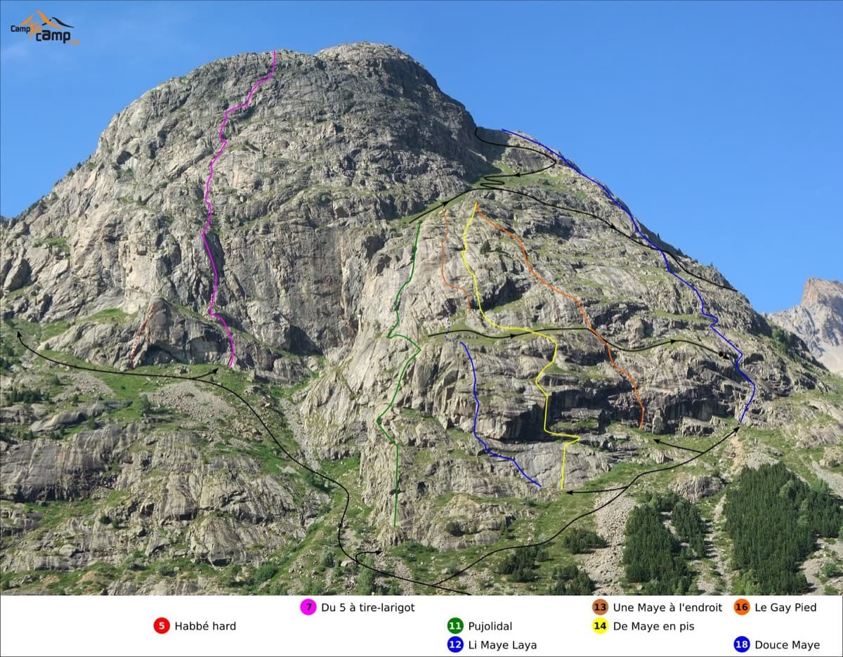
Routes on the south face of the Tête de la Maye; Pujolidal is the green line (number 11)

France · La Bérarde (Écrins)

Pujolidal

The great classic of the Tête de la Maye: 13 pitches of rounded granite slab above La Bérarde with nothing athletic until the last hard pitch, a flake and wide crack of 5c+ that everyone remembers. Recently rebolted and very closely protected. It is camptocamp's reference route for the overall grade D.

5c+13 pitches350 m
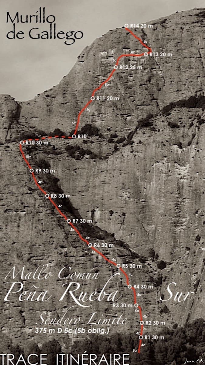
Topo of Sendero Límite on the south face of Peña Rueba (Mallo Común)

Spain · Riglos & Agüero (Mallos)

Sendero Límite

A long beginner's big route on good conglomerate at a moderate angle. Pitches can be linked in pairs with a 60 m rope. A four-pitch headwall with a couple of panzas finishes high above the Gállego valley.

5c14 pitches375 m

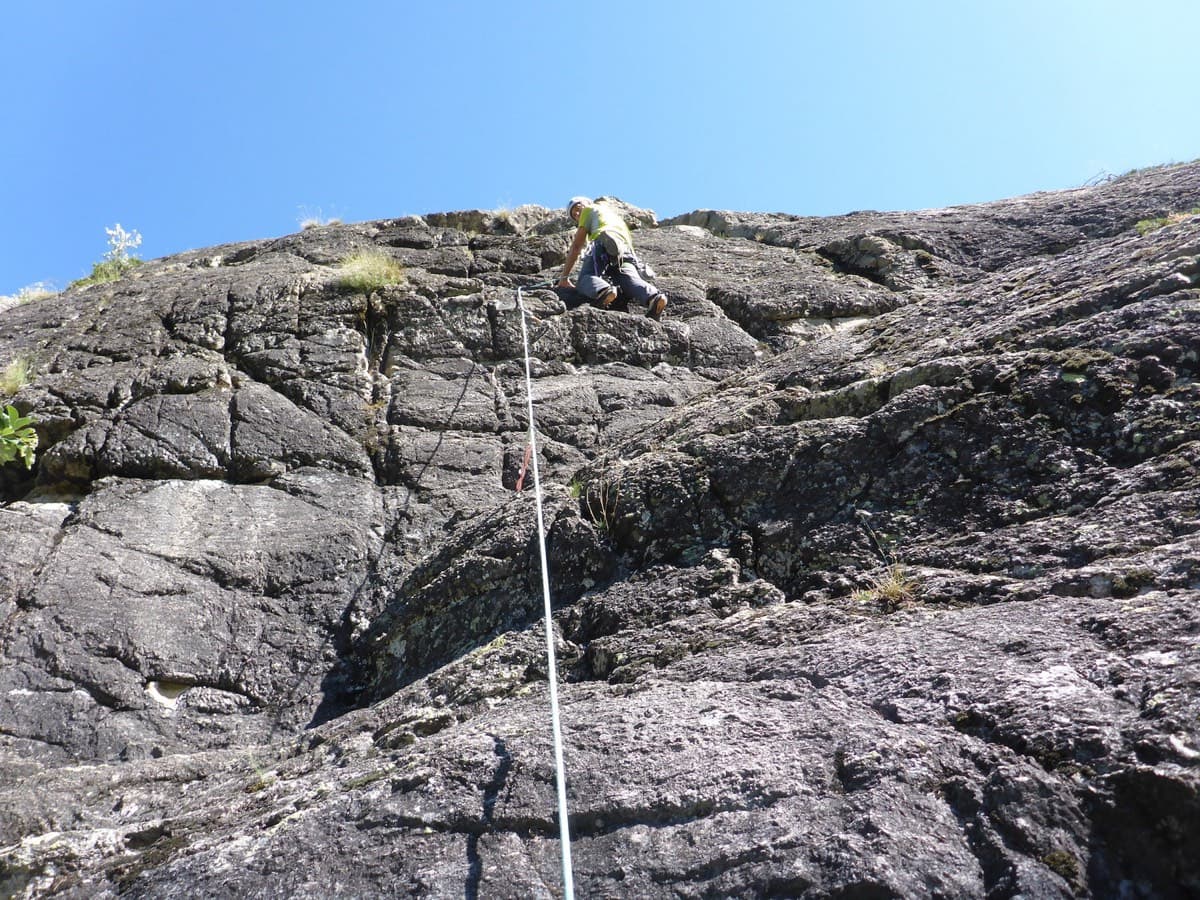
Climber on pitch 3 or 4 of Les Pets des Rupricaprins, La Draye, Ailefroide

France · Ailefroide

Les Pets des Rupricaprins

A long, sunny outing up a series of granite steps, consistently in the 5th grade, finishing with a great view over La Draye. Grassy ramps separate the tiers, so the climbing never feels exposed.

5c14 pitches450 m

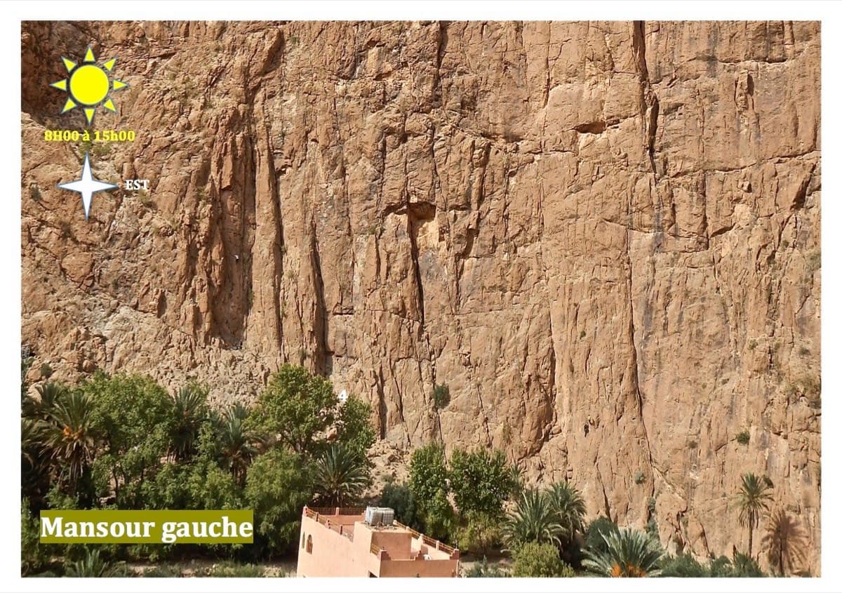
Mansour Gauche sector, Todra Gorge

Morocco · Todra Gorge (Todgha)

Berbertraum

Thirteen short pitches, mostly grade 4, with two 5c steps. The longest pitch is 45 m. A big day of easy mileage in the sun above the palm grove.

5c13 pitches340 m

Compiled from published sources and last verified October 2026. Bolts, anchors and access change. Climbing is dangerous and you are responsible for your own decisions: check a current topo and read the disclaimer.